Точное позиционирование в реальном времени с точностью до сантиметра имеет решающее значение в таких областях, как автономное вождение, точное земледелие и аэрофотосъемка с помощью дронов. Система GNSS/INS I3700 с двумя антеннами от Micro-Magic расширяет возможности технологии RTK, преодолевая такие ограничения, как перекрытие сигнала, и обеспечивает точную и надежную навигацию в сложных условиях. Эта система обеспечивает надежное позиционирование для приложений нового поколения.
В таких областях, как автономное вождение, точное земледелие и аэрофотосъемка с помощью дронов, позиционирование в реальном времени с точностью до сантиметра стало ключевым требованием. Технология Real-Time Kinematic (RTK) уменьшает ошибки традиционного GPS-позиционирования с метров до сантиметров благодаря взаимодействию базовой станции и ровера. Появление высокопроизводительной интегрированной навигационной системы GNSS/INS с двумя антеннами I3700 от Micro-Magic обеспечивает RTK улучшенную адаптивность к окружающей среде и надежность, открывая новую эру высокоточного позиционирования.
Система RTK обеспечивает точное позиционирование за счет взаимодействия базовой станции и ровера:
Базовая станция: Расположенная в известных координатах, она вычисляет ошибки спутникового сигнала в реальном времени (например, атмосферную задержку, дрейф часов).
Ровер: получает данные коррекции ошибок от базовой станции и объединяет их со своими собственными наблюдениями для определения местоположения с точностью до сантиметра.
Работа в режиме реального времени: передача данных по протоколам 4G/NTRIP с <Задержка 20 мс
Техническое узкое место: Традиционный RTK не справляется с передачей сигнала при его перекрытии (туннели, городские каньоны) и не может предоставлять данные об ориентации несущей.
Модуль I3700, представляющий собой высокопроизводительный комплекс, объединяющий двухантенную систему GNSS и инерциальную навигацию (INS), преодолевает ограничения RTK благодаря трем инновациям:
Базовая ориентация: расстояние между антеннами A/B: 0,8–1,5 м; калибровка по оси Y несущей с помощью команды SETBASELINE.
Точность определения курса: 0,2° (при использовании фиксированного решения RTK), что значительно превосходит точность GPS с одной антенной (погрешность 2°–5°).
Функция защиты от окклюзии: поддерживает заданный курс при потере сигнала GNSS с помощью гироскопа со стабильностью смещения 2,5°/час.
# Рабочий процесс расширенного фильтра Калмана (EKF) while True: gnss_data = get_rtk_position() # Получение RTK-позиции imu_data = read_mems() # Чтение угловой скорости/ускорения MEMS wheel_speed = can_obd2_decode() # Декодирование скорости автомобиля по шине CAN fused_position = ekf_fusion(gnss_data, imu_data, wheel_speed)
Поддерживаемые периферийные устройства: одометры, доплеровские измерители скорости (DVL), датчики визуального контроля.
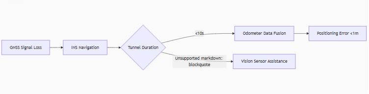
Непрерывная навигация: ошибка горизонтального позиционирования. <6 м в течение 60 секунд после потери сигнала GNSS (с вводом данных одометра)
| Параметр | Спецификация | Преимущество отрасли |
|---|---|---|
| Степень защиты | Водонепроницаемость IP68 | Грязная среда на фермах/морских судах |
| Диапазон температур | от -40°C до 85°C | Экстремальные условия холода/жары |
| Источник питания | 6–36 В постоянного тока с широким диапазоном напряжений | Прямое потребление энергии транспортным средством |
| Сертификация | CE/ROHS | Соответствие экспортным требованиям |
Задача: Затенение сигнала на сельскохозяйственных угодьях приводит к отклонению траектории движения во время автоматизированных операций.
Решение I3700:
Две антенны обеспечивают стабильное направление, позволяя осуществлять навигацию с точностью до ±2,5 см между рядами с использованием RTK.
INS поддерживает <Ошибка в 1 м в течение 10 секунд при частичном перекрытии деревьями.
Команда: CONFIG MODEL CAR активирует ограничения движения транспортного средства.
Основные параметры конфигурации: вывод объединенных навигационных данных с частотой 20 Гц через LOG INSPVAXB ONTIME 0.05
Точное зависание: точность позиционирования 0,8 см + 1 ppm при фиксированном решении RTK.
Ветроустойчивость: акселерометр с частотой 150 Гц компенсирует боковые ветровые помехи.
Передача данных: интерфейс RS-422 передает двоичные данные RAWIMUXB (необработанные данные IMU).
Многопротокольные интерфейсы I3700 обеспечивают безграничные возможности системной интеграции:
Облачное сотрудничество: доступ к Qianxun/China Mobile CORS через 4G DTU
CONFIG NTRIP rtk.ntrip.qxwz.com 8002 AUTO qxx 123456 # Настройка учетной записи Qianxun
Автомобильная связь: выходы SAE J1939 PGN65341 (ориентация)/PGN65345 (курс)
Синхронизированное срабатывание: импульс PPS + контакт SYNC_IN синхронизируют сканирование LiDAR.
Система RTK обеспечивает абсолютную точность позиционирования, а системы GNSS/INS, такие как I3700, гарантируют устойчивость к воздействию окружающей среды и точность определения ориентации. Вместе они образуют «пространственно-временное двухъядерное ядро», преодолевающее «последний сантиметр» разрыва для автономного вождения, интеллектуального сельского хозяйства и робототехники.

Xml политика конфиденциальности блог Карта сайта
Авторские права @ Микро-Магия Инк Все права защищены.
 ПОДДЕРЖИВАЕТСЯ СЕТЬ


 русский