A pure inertial navigation system (INS) relies entirely on internal gyroscopes and accelerometers; it receives no external signals and possesses strong anti-interference capabilities. However, its application is constrained by navigation errors that grow without bound over time (drift). Starting from the INS mechanization equations, this paper derives an analytical model for error propagation, defines the boundary conditions for the viability of pure inertial navigation, and provides recommendations regarding drift tolerance and recalibration intervals for typical scenarios.
The navigation equations for a strapdown INS are:
Conducting a perturbation analysis of device errors (bias, scale factor, and random walk), the position error under static-base conditions in the Laplace domain is expressed as:
Here, ∇ represents accelerometer bias, ε denotes gyroscope drift, and ω_s = √(g/R) is the Schuler frequency. This equation reveals the fundamental characteristics of the drift: the vertical channel error diverges exponentially, the horizontal channel error exhibits oscillation superimposed on linear growth, and the azimuth error accumulates linearly over time.
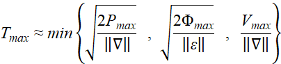
An approximate constraint on the maximum operating duration for pure inertial navigation can be derived from the error model:
This relationship indicates that the mission duration must be shorter than the drift time constant, which is determined by a combination of device bias and allowable error tolerances. For short-duration missions (e.g., 3–10 minutes for the mid-course phase of a missile or 5–30 minutes for indoor UAV operations), tactical-grade or even MEMS-based inertial navigation systems (INS) are sufficient on their own. Long-endurance submarine missions (spanning hours to days) require navigation-grade components; however, kilometer-level drift over a 24-hour period remains inevitable, necessitating supplementation with gravity or geomagnetic matching. Conversely, deep-space cruising missions lasting several months are entirely unfeasible without reliance on celestial navigation for corrections. The engineering rule of thumb is that standalone INS is viable if drift remains below the threshold within the mission window; otherwise, a recalibration mechanism must be implemented.
The suitability of standalone INS depends on the alignment between mission duration and device precision. For short-duration missions (e.g., 3–10 minutes for missile mid-course flight or 5–30 minutes for indoor UAV operations), tactical-grade or even MEMS-based INS units are capable of independent operation. For long-duration missions (e.g., submarine operations lasting hours to days), even navigation-grade devices cannot avoid kilometer-level drift over 24 hours, requiring periodic recalibration via gravity or geomagnetic matching. Civil autonomous vehicles (operating for 10–60 minutes) can utilize zero-velocity updates (ZUPT) during stops, while infantry personnel on foot can use gait-based ZUPT to constrain MEMS drift to within 5% of the total distance traveled. In contrast, for extremely long-duration scenarios such as deep-space cruising, even the highest-precision INS cannot operate independently. The engineering guideline is that standalone INS is acceptable if drift stays within the threshold during the mission window; otherwise, a recalibration mechanism must be integrated to strike a balance between autonomy and accuracy.
To enhance the viability of standalone INS, the following strategies are commonly employed in engineering to extend the time before drift becomes excessive:
· Zero-Velocity Update (ZUPT): Velocity is reset to zero during periods of stationarity, eliminating accumulated velocity errors and indirectly suppressing positional drift. Performing this update every 30–60 seconds can significantly improve the performance of MEMS-based INS. Barometric altitude aiding: Uses a barometer to provide an absolute altitude constraint, suppressing the divergence of the vertical channel error.
· Motion constraints (NHC): Utilizes pseudo-observations of zero lateral and vertical velocity (applicable to vehicles and ships) to reduce the horizontal drift rate.
· Periodic resetting: Resets position, velocity, and attitude upon receiving external reference information (even non-satellite-based) at predetermined times or locations.
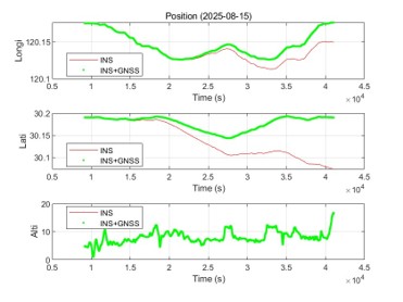
The figure below compares the positioning trajectories of a standalone Inertial Navigation System (INS) and an INS/GNSS integrated navigation system. The standalone INS (red) drifts away from the true path as errors accumulate over time; in contrast, the INS/GNSS system (green) effectively constrains the drift close to the true trajectory through periodic GNSS corrections. This diagram visually demonstrates that standalone INS errors grow without bound, necessitating external aiding or periodic resetting for long-duration missions.
The application scenarios for pure inertial navigation can be summarized as environments characterized by short durations, high dynamics, an absence of external signals, and a tolerance for limited drift (e.g., missiles, UAVs, and short-range underground or underwater missions). The core constraint is the error growth rate determined by device bias and random walk, quantitatively defined by the relationship $T_{max} \propto \sqrt{P_{max}/\nabla}$. In practical system design, it is essential to consider mission duration, accuracy requirements, and component selection; this involves planning recalibration strategies in advance and integrating pure inertial navigation with auxiliary methods to achieve an optimal balance between performance and autonomy.
оставить сообщение
Отсканируйте QR-код для отправки в WeChat :